
By Brad Goodfellow
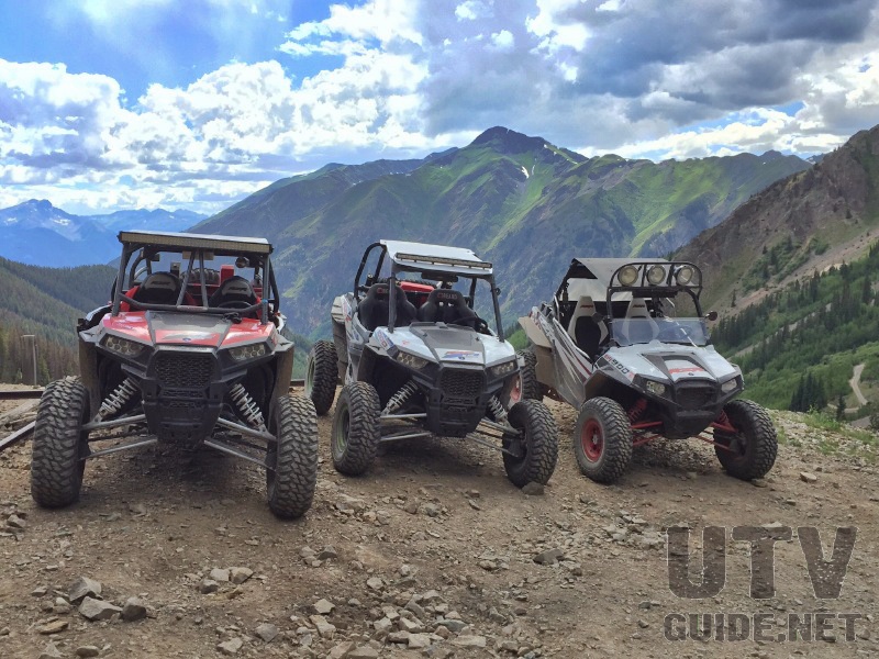
High in the San Juan Mountains of south western Colorado awaits an alpine UTV adventure like no other. After hearing statements, stories, & reports like this from several different sources we decided to make a late summer trek to Colorado and see the area for ourselves.

Silverton Colorado
For this trip, the tiny town of Silverton would serve as our base. Silverton is an 1800s era mining town of only 640 residents & sits at 9,300 ft elevation. Founded in 1874 the little town is made up mostly of old original buildings, including hotels, restaurants, bars, & small shops. Besides the few small 1800s style hotels there are four privately owned full service campgrounds located within the town limits. Driving UTVs is allowed in Silverton on designated routes including the main route right through the middle of town. Silverton has only one gas station however, and unfortunately due to Colorado State regulations it isn’t accessible to UTVs. For this reason visitors should be prepared with gas cans, or to trailer their UTV across Highway 550 to reach the gas station.

Mining Ruins on the Alpine Loop
After arriving, unloading and settling into camp we set about planning out our rides. The most popular attraction in the area is a 65 mile route known as The Alpine Loop where the trail crosses over two high mountain passes that exceed 12,000 ft elevation. Furthermore as the spectacular loop trail traverses the San Juan mountains you pass amongst seemingly endless mountain peaks, six of which tower over 14,000 ft elevation. The “Loop” serves as a main route with several incredibly beautiful steep canyon & gulch trails extending out from either side.

Incredible Scenery of the San Juan Mountains
The entire area provides hundreds of miles of trails and is rich in early mining history, including many explorable old mining settlements and ruins. The alpine scenery of the area is like nothing we have experienced on any previous outing. The exceptionally rugged high country is dominated by flowing water. Brooks, streams, waterfalls and rivers seem to flow down every drainage, all of which are fed by the prevalent springs and giant snow patches that dot the high country landscape.

Cinnamon Pass
Even in late summer everything was green and the plentiful alpine flowers were incredible! Equally as impressive as the scenery is the heritage and engineering feats of the 18th century miners that extracted precious metal ore from the incredibly rugged mountains.

During our days rides we spent hours exploring the many mining ruins that are up and down nearly every trail. The trails of the area ranged from smooth, wide and fast, to narrow, twisty, and steep including many ‘don’t look down’ moments.

Poughkeepsie Gulch Trail
There are a few routes that are rated ‘Expert’, however easier by-pass routes around the tougher obstacles are well marked. In the six days that we spent exploring the area we logged in excess of 350 miles in our UTVs and still weren’t able to hit nearly all of the trails in the area.

Picayne Gulch Trail
Due to the elevation and the heavy winter snows the trail system is typically only accessible between June & September. Go prepared for rapidly changing summer weather conditions. While we were there we experienced temperatures ranging from the mid 70s to the high 30s as well as short periods of rain and hail.

Maggie Gulch Trail
Navigating the trail network was never an issue. All routes are well marked and there are several different trail maps available for the area both online and at various businesses in the area. Our favorite was actually the Alpine Loop GPS map that we downloaded for free using the Avenza PDF app. We were able to use our GPS enabled wireless device to see exactly where we were on the map at anytime, despite not having any type of wireless service.

Alpine Loop Map
Looking back we had a very enjoyable trip and definitely plan to return to the area to continue exploring and taking in all of the incredible beauty Colorado offers.

PoughkeepsieGulchTrail
More information on the Alpine Loop:
The Alpine Loop is part of the National Scenic Byway system — a selection of the country’s most scenic roads identified and managed for the enjoyment of the millions of people who drive for pleasure. Unlike most scenic byways, which are located on paved highways, back country byways focus on the out-of-the-way sights to be found on gravel and dirt roads. These are routes that may not be suitable for all vehicles. However, for those with appropriate vehicles, the back country byway program can offer an intimate view of a variety of areas off the beaten path.
The Alpine Loop is one of the outstanding examples of the back country byway system. It covers 65 miles of roads between the towns of Lake City, Ouray, and Silverton. Depending on winter snows, the Loop opens about late May/early June and closes in late October. About two thirds of the route is dirt road suitable for 2-wheel-drive cars, so everyone can experience a portion of this scenic area. In order to traverse the entire route, however, you will need a 4-wheel-drive, high clearance vehicle. If you don’t have such a vehicle, you can rent one in the surrounding communities or take a tour that allows you to sit back and enjoy the scenery. Wherever you venture along the route you will be surrounded by the best the Rocky Mountains have to offer.
Tucked away in the San Juan Mountains of Southwestern Colorado is one of the true gems of our public lands. Sculpted by the forces of volcanoes, glaciers, and wind and rain, the resulting mountains, valleys, streams, and lakes are a masterpiece of nature’s artistry. Native Americans came to these mountains for centuries to hunt and gather food. In the late 1800s they were replaced by miners who came in search of a different livelihood — silver, gold, lead, and zinc. These hardy pioneers carved a network of roads through this rugged terrain to enable them to transport ore and supplies by mule-drawn wagons.
Today, most of the mines are closed but the roads still remain. They are used by a different sort of adventurer – folks who travel by 4-wheel-drive or motorcycle or mountain bike. Although technology has made it easier for us to visit these mountains, it has not diminished their beauty or the adventure to be found here. One thing that has changed is the name.
We now call this system of roads the Alpine Loop National Back Country Byway. Most of the area is public land managed for you by the Bureau of Land Management and the US Forest Service. It is wild country and perhaps not suited to everyone’s taste. But, if you are able to appreciate nature on her own terms, we think you will agree this is a very special place.
No Comments