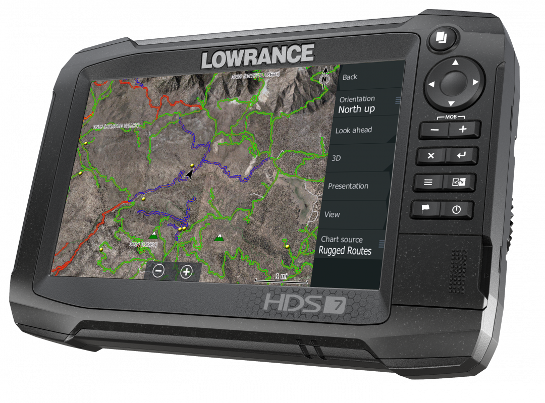
Fontana, Calif. – Off-road enthusiasts want to be guided through desert or forest with ease and often try to use apps on their phones only to find that cell service is often compromised. That problem is solved by Rugged Routes, a company that produces high-resolution satellite maps loaded on an SD card designed exclusively for Lowrance GPS devices.
The map can be adjusted to show full-width vehicle forest service trails, 50-inch track OHV trails or 24-inch track motorcycle trails — all with colored trail ratings. The map can also display hiking trails, group campsites, group campgrounds, equestrian campgrounds, individual campsites and mountain peaks. The map can also display Bureau of Land Management roads and boundaries and U.S. Forest Service routes and boundaries in addition to nearby highways.
“A Lowrance GPS is far more durable than using an app on a phone, and tracks speed and positioning far more accurately,” said Founder and President of Rugged Routes Steven Lutz. “The Rugged Routes SD card stores the map and eliminates the need to pre-plan and download your trip before you go to a different OHV area.”
Some of the most popular maps include:
- San Bernardino National Forest, Calif.
- Johnson Valley, Calif.
- Glamis Dunes, Calif.
- Funtreks Guide to Colorado
- Funtreks Guide to Moab, Utah
The maps start at $99 and can be purchased at RuggedRoutes.com. A map is also available for you to download and demo the product.
The Funtreks Guide maps by Rugged Routes expand upon Funtreks GuideBooks available at Funtreks.com. Unlike the Funtreks gpx maps, Rugged Routes features the trails in the book, plus the surrounding roads and trails with the entire book paraphrased in the map. When you select a way-point or trail-head, it will show you additional information from the book. All the trails are color coded according to trail difficulty, and it’s displayed on hill-shaded satellite imagery.
“Rugged Routes is continuously working to map new areas for off-road enthusiasts to seamlessly travel using their Lowrance GPS device,” Lutz said. “If we don’t have a map in an area you’re looking to explore, send us a request on our website.”
Lowrance GPS units are also available for purchase at RuggedRoutes.com.
“Lowrance products are widely known in the marine industry, but have a lot of capabilities when it comes to off-road,” Lutz said. “Many Baja racers have been using Lowrance devices to race for over a decade.”
The newest model, the HDS Carbon, features a high-definition, touch display with LED backlighting and an anti-reflective coating that allows the screen to be viewed from nearly any angle. The dual-core, high-performance processor allows for faster redraw speeds.
Wireless and Bluetooth connectivity is integrated and a network analyzer alerts users when a software update is available.
It will be available for purchase beginning in March starting at $1,249. Rugged Rocks, LLC, the parent company of Rugged Routes, was established in 2005 by Steven Lutz. Rugged Routes is an off-road satellite map development company that has mapped off-road areas since 2014. More information about the products available can be viewed at RuggedRoutes.com.